Cartography Study - Learning how to survey and make maps
Cartography unit plan & activities
The great thing in this world is not so much where we are, but in what direction we are moving. Oliver Wendell Holmes
Overview
- Overview
- Big ideas, concepts, facts, & outcomes
- Inquiry & science process concepts
- Pedagogical overview
- Activities sequence
- Focus questions
- Materials
- Scoring guide suggestions
- Unit activity sequence
- Activity 1 - 9 Map investigations
- Activity 10 - Treasure map? investigation
- Activity 11 - Camp Map exploration
- Activity 12 - Yard Map Investigation
- Activity 13 - Review Cartography vocabulary
- Activity 14 - Lost at Sea
- Activity 15 - Map making & photo log
- Lab notes
- Lab note 1 - Map investigations
- Lab note 2 - Points of interest
- Lab note 3 - How far?
- Lab note 4 - How big?
- Lab note 5 - How many counties?
- Lab note 6 - Highways
- Lab note 7 - Measuring distance
- Lab note 8 - Directions
- Lab note 9 - More directions & GPS
- Lab note 10 - Treasure map
- Lab note 11 - Camp Map exploration
- Lab note 12 - Yard Map Investigation
- Lab note 13 - Review Cartography vocabulary
- Lab note 14 - Lost at Sea
- Lab note 15 - Map making & photo log
- Lab note - Counting steps for distances
- Support materials
- Types of Maps
- Map vocabulary
- Map making vocabulary
- Counting steps for distances - How far by steps?
This article includes information to organize a study for learning about maps and how to make them (Cartography). The topics are for upper elementary or middle level. Information includes activities and questions to review map skills and moves into learning different strategies for mapping places and making different kinds of maps.
Rationale
- Real life application
- Useful to locate places and objects
- Increase visual and spatial reasoning
- Provides information about places
- Inexpensive to acquire
- Develop reasoning and problem solving
- Develop math and science concepts and skills
- Develop logic, critical thinking, and problem solving
Background resources:
This plan is designed for learners who have very little prior knowledge of maps and map making. However, they should have experiences with relative position as in the relative position and motion unit or similar sequence.
Related study topics:
- Orienteering
- Carry on Mr. Bowditch - Historical fiction about young man at sea and navigation in 1800's - 1955
- The Last Mapmaker - Historical fiction about a young woman at sea and cartography. - 2022
Planning information
Learner background information
A plan designed for learners who have prior knowledge in cause and effect, use of observations to make inferences, models as explanations for observable and non observable events, relative position, and working in groups.
Intended learnings & learners thinkings
Content Big ideas, concept & facts, & outcomes
(Source concepts & misconceptions)
Big ideas
- Maps are diagrams that represent of an area of land, sea, or space. They show the relationships of real physical objects, events, or classes of objects or other features related to the geography or human activities.
- Objects can be located with different combinations of distances and directions from a singular point or multiple points.
- One point as a reference object can be used to locate another point or object with a distance and direction.
- An object or point can be located from two known points with a distance and direction from one point and either a distance or a direction from the second point.
Concepts and facts
1. Distance can be measured by pacing
- The length of a person’s pace may vary.
- The average of a person’s pace can be used to measure between two places by counting the number of paces and using that with the average length of the pace to measure the distance.
- A person can measure the length of a pace by counting the number of paces a person makes over a known distance and find an average.
2. The position of an object can be located from a baseline if the distance along the baseline, from a benchmark/ datum, is known and the distance to a point at a 90-degree angle from the baseline.
- A baseline is a straight line from a benchmark/ datum.
- A baseline can be visualized with a string or cord attached to a benchmark/ datum and pulled straight.
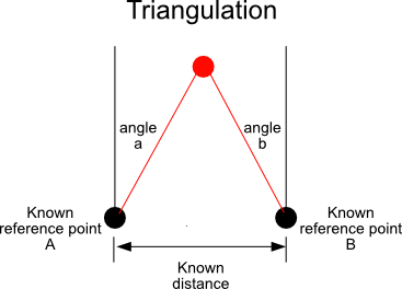
3. Positions of objects or features can be located to a benchmark/ datum, by triangulation.
- Triangulation is a procedure used to locate positions by dividing a region into a series of triangular pieces based on lines of known length that intersect at the point to be located; and the other ends of the lines join the base of a triangle of known length between a benchmark/ datum and another known point (another selected benchmark/ auxiliary datum).
4. Positions of objects can be located from a benchmark/ datum with a direction (azimuth) and distance.
- Direction of an object can be measured in degrees using a transit located at a benchmark to measure the angle of declination from north (azimuth).
- Distance can be measured from the same benchmark to the object using paces or measuring cord.
5. Contours can be mapped by measuring distance from a baseline.
- Baseline is used to measure contours. It can be made by extending a cord over the contour so that it is level with the Earth, measuring intervals of distances from a benchmark/ datum/ (start of the baseline) along the cord and then measuring the distance from the points on the cord of each interval distance to the point on the contour directly below (perpendicular to) the cord/baseline.
6. The height of a tree, flagpole, building or some other object can be measured with a grade/slope/angle/ and a known distance.
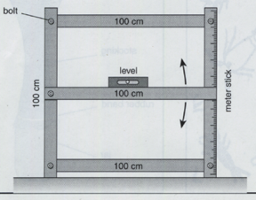
7. The grade/slope/angle of a surface can be measured with a clinometer or slope measuring device as in the diagram below.
Outcome
- Identify geographical aspects of the land (mountains, deserts, plains, swamps, lakes, rivers, oceans.
- Locate positions on a map.
- Locate points using one distance and one direction.
- Calculate actual Earth distances from a scale on a map.
- Locate points using two distances.
- Determine direction from a map.
- Locate points using two directions.
- Draw Earth distances to scale on a map.
- Use a contour map.
Anticipated learner thinkings & misconceptions
All learners from middle level up need multiple experiences with relative position, visualization, measuring, scale, and organizing information to communicate directions.
Inquiry, process, & cross cutting concepts & skills
Inquiry
- Maps are diagrams that represent of an area of land, sea, or space. They show the relationships of real physical objects, events, or classes of objects or other features related to the geography or human activities. Types Of Maps
- Skills of observations, properties, communication, representation, relative position, measurement, and scale are used to make maps and read them to locate objects and features relative to points of reference to make claims, explain what is happening, and to predict what might happen in the future.
- Inquiry concepts - in science knowledgebase
- Process concepts - in science knowledgebase
- Perspective concepts - in science knowledgebase
Cross cutting
Relative position
Objects can be located with different combinations of distances and directions from a singular point or multiple points.
- One point as a reference object can be used to locate another point or object with a distance and direction.
- An object or point can be located from two known points with a distance and direction from one point and either a distance or a direction from the second point.
See more about misconceptions & naive understandings
Related concepts and facts
- Observational data and reasoning is used to locate objects.
- An object is located relative to a reference object.
- Maps are diagrams that represent of an area of land, sea, or space. They show the relationships of real physical objects, events, or classes of objects or other features related to the geography or human activities.
- Maps can communicate evidence of something
is observed and can be used to understand what is happening to communicate location and relationships.
- Maps are diagrams that represent of an area of land, sea, or space. They show the relationships of real physical objects, events, or classes of objects or other features related to the geography or human activities.
- Explanations are based on observations derived from experience.
- Pictures or symbols can represent objects.
Outcome -
- Use a map to locate where they are and use them to give directions to different locations.
- Make maps of local locations.
Specific outcomes -
Other possible concepts
History of science and development of technology - perspective of science
See also Concepts & misconceptions also science, math, technology timeline
- Maps have been of great value to people from ancient times.
- People have practiced science and technology for a long time.
- Science develops over time.
- Science investigators such as
Scoring guides suggestions (rubric)
Maps (scoring guide)
Top level
- Map indoor and outdoor spaces by using distance, directions, and scale to accurately locate and represent different objects and their locations.
- Locate points on a map, determine distance, use distance and directions to write directions from a reference point to other places on a map.
- Use a map to give directions from one place to another.
- Locate points of interest on a map.
Lower level
Strategies to achieve educational learnings
Based on learning cycle theory & method
Instructional Procedure
Pedagogical Overview
Activities Sequence to provide sufficient opportunities for students to achieve the targeted outcomes.
Make sure learners have the prior knowledge identified in the background information.
- Activity 1 - 9 Map investigations
Moving beyond using maps to Making Maps - Cartography
- Activity 10 - Treasure map
- Activity 11 - Camp Map exploration
- Activity 12 - Yard Map Investigation
- Activity 13 - Review some Cartography vocabulary
- Activity 14 - Lost at Sea
- Activity 15 - Making maps & photo log
- Counting steps for distances - How far by steps?
Focus question
Unit focus question:
What are maps and how are they used and made?
Sub focus questions:
- What is a map?
- How are maps used?
- How are maps made?
Materials
- Maps and instruments to make them. transit, clinometer, meter tapes, protractor, compass, paper, pencils
- Lab note 1 - Map investigations
- Lab note 2 - Points of interest
- Lab note 3 - How far?
- Lab note 4 - How big?
- Lab note 5 - How many counties?
- Lab note 6 - Highways
- Lab note 7 - Measuring distance
- Lab note 8 - Directions
- Lab note 9 - More directions & GPS ... See Brad Parkinson and global positioning (GPS)
- Lab note 10 - Treasure Map? investigation
- Lab note 11 - Camp Map Exploration
- Lab note 12 - Yard map investigation
- Lab note 13 - Review some Cartography vocabulary
- Lab note 14 - Lost at Sea
- Lab note 15 - Making maps & photo log
- Counting steps for distances - How far by steps?
Resources
Lesson Plans
Activity 1 - 9 Map investigation
Materials
Focus questions:
- How do we read and use maps?
Learning outcomes:
- Explore maps and locate points of interest, determine distance, size of cities, locate counties, use distance and directions to write directions from a reference point to another place on a map.
Suggested procedures overview:
- Put learners in groups, focus their attention, and assess their initial understanding of the focus questions.
- Activity - Explore maps and locate points of interest, determine distance, size of cities, locate counties, use distance and directions to write directions from a reference point to another place on a map.
Exploration -
- Put learners in pairs.
- Tell. You are going to explore your map, discover what it represents by selecting an activity from the following.
- Find points of interest. Find and identify points of interest and estimate how many are on the map: cities, people,
towns, lakes, rivers, camping areas, parks, capitals, museums, schools, …
- Find and make a list of your top ten points of interest.
- Make a graph of cities by their first letter.
- Make a graph of cities according to the number of syllables they have.
- Make a graph by how many cities in each county.
- Which city has the most letters, vowels, consonants, …
- Locate cities by coordinate pairs (15 K) use colored yarn to show (red, yellow)
- Locate positions by latitude and longitude
- What is the highest elevation?
- What is the highest lowest?
- How many time zones?
- Write and answer, How far ... How from x to y, by highway, by air, by river, between airports, across Lakes …
- How big is a city, county, state, country. How wide is the …. How long is … What is the area of ... What does wide and long mean? Can there be more than one answer? How does it compare to area?
- How many counties? largest? smallest? (area?, population?)
- What kinds of highways are there. Where do the meet, intersect, interchange. How many interstates? How many exits on interstate ……. ?
- Measure distance. What is the average between exits? Where could you travel on a tank of gas? Chart the lengths of ___ rivers. If there are historical trails or routes, how long are they?
- Directions. Choose a town at random, give directions on how to get there from here. Turn around and give directions in reverse. How are they different? How are they the same?
- Distance and direction. Plan a trip from a city that starts with the letter A to a city that starts with the letter B to … letter Z ? In a state. How far would the trip be? What directions and distances can be given to another person travel from start to finish. If you traveled from …………. to ………………. what alternative routes would give different distance? Check with Google map, WAZE, or other GPS service. Why do these services give two different types of directions?
- Find points of interest. Find and identify points of interest and estimate how many are on the map: cities, people,
towns, lakes, rivers, camping areas, parks, capitals, museums, schools, …
Invention -
- Exchange with groups and share with class to explain and discuss their activity.
- Ask. What kinds of questions can we use maps to answer?
Discover
More math and geography investigations or projects
- What is the cost to build a mile of interstate, other road…
- How much did interstate …………. cost?
- Highway …….. cost?
- What percent of each border is land? water? bordering state …………… , state ………...
- If you left at ………. and traveled to …………. about what time would you arrive (not breaking any speed limits now).
- If the Mormons left Omaha on ………. and traveled ………… miles a day where would they be on ……………
- If a person left on the Oregon trail and traveled ____ miles a day, when would they arrive in Oregon?
Activity 10 - Treasure Map investigation
Materials:
Focus questions:
- Can you use a map to locate a treasure?
Learning outcomes:
- Explore the note and use the map to locate a treasure?
- Identify procedures to locate objects relative to known positions with the use of distances and directions.
Suggested procedures overview:
- Put students in groups, focus their attention, and assess their initial understanding of the focus questions.
- Activity - Explore the treasure note and map and find the boxes location.
- Identify procedures to locate objects relative to known positions with the use of distances and directions.
Exploration
- Put students in pairs.
- Tell. Read the note found in an old attic and locate on the map where the treasure box might be located.
- Have learners draw their locations to share with the class.
Invention
- Have learners share their locations and explain their reasoning until everyone agrees.
- Ask. What did you use to locate the treasure? Distance form a known position (reference point)
- Can you make a general statement about a procedure to locate objects relative to a known position with the use of a distance? A distance from a known point will locate points along a circle. A distance from a line will locate a line equal distance from the line. If two such locations intersect at unique points that narrows down (eliminates or identifies) possible locations.
Discover
- Try the next map
Activity 11 - Camp Map exploration
Materials:
Focus questions:
- Can you use a map to answer questions?
Learning outcomes:
- Explore the Camp map and answer the related questions.
Suggested procedures overview:
- Put students in groups, focus their attention, and assess their initial understanding of the focus questions.
- Activity - Explore the Camp map and answer the related questions.
Exploration
- Put students in pairs.
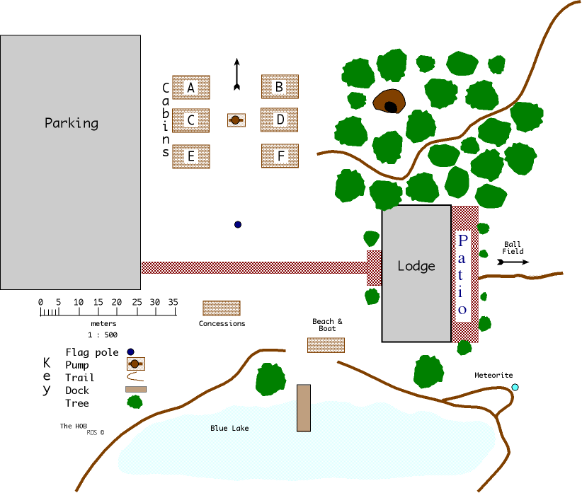
- Tell. Locate the Camp map map and use it to answer these questions:
Questions for Camp Map
- If you were at the pump which of the following could you see better?
- a. ball field
- b. head of the woods trail
- c. the flag pole
- d. the dock
- What direction is cabin F from cabin B?
- Using the pump and flagpole as a base line locate the cave.
- Starting at the flagpole use one direction (azimuth) and distance to locate the cave.
- How many meters long is the sidewalk from the parking lot to the lodge?
- What direction is the ball field from the lodge?
- What are the dimensions of the lodge?
- Use an azimuth (direction from north) and direction to locate the meteorite.
- What cabin is directly east of C?
- What cabin is west of F?
- Why can’t you locate the ball field?
- What is located on the lake?
- What is the scale of this map?
- Where does the needle of a compass point?
- One cm on the scale is how many meters?
- In real life 1 m = cm
- In real life 1 km = m
- In real life 1 m = mm
Bonus Question 1 inch on the map is equal to how many inches on the Earth?
Invention
- Have learners share their answers and explain their reasoning until everyone agrees.
- Have learners share their locations and explain their reasoning until everyone agrees.
- Make general statements about the procedures you used to locate objects relative to a known position.
- Ask. What kinds of questions can we use maps to answer?
Discover
- Try the next map
Activity 12 - Yard Map Investigation - Where to build?
Materials:
Focus questions:
- Can you use a map to locate a building site?
Learning outcomes:
- Identifies a building site based on flooding information and building specifications.
- Make general statements about procedures to locate objects relative to known positions with the use of distances and directions?
Suggested procedures overview:
- Put learners in groups, focus their attention, and assess their initial understanding of the focus questions.
- Activity - Identify areas based on information and describe procedures to locate objects relative to known positions with the use of distances and directions.
Exploration
- Put learners in pairs.
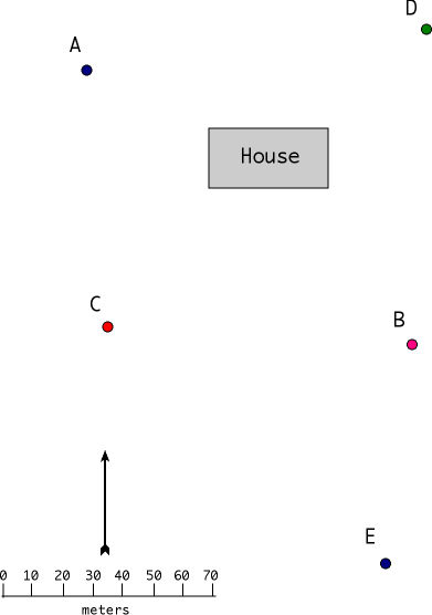
- Tell. Locate the House and yard map and use it to answer these questions:
- What direction is point B from point A?
- Using points A and B as a baseline locate point C.
- Starting at point C use one direction and one distance to locate point D.
- How many meters from C to E?
- Use an azimuth and a direction to locate point C from point B.
- What point is south of B?
- What point is west of B?
- What direction is D from C?
- What direction is A from C?
- What direction is C from A?
- What direction is C from E?
- What are the dimensions of the house?
Bonus: Which two of the following are in the Northern Hemisphere?
Arctic Circle, Antarctica Circle, Tropic of Cancer, Tropic of Capricorn
Invention
- Have learners share their answers and explain their reasoning until everyone agrees.
- Ask. What did you use to locate a site? Distance form a known position (reference point)
- Can you make a general statement about a procedure to locate objects relative to a known position with the use of a distance? A distance from a known point will locate points along a circle. A distance from a line will locate a line equal distance from the line. If two such locations intersect at unique points that narrows down (eliminates or identifies) possible locations to points, lines, or areas.. A direction and distance from a known point will locate another point.
- Ask. What kinds of questions can we use maps to answer?
Discovery
- Want to make a map of ... playground ... school yard .... park .... other?
Activity 13 - Review Cartography vocabulary
Materials
Focus questions:
- What are some map related vocabulary?
Learning outcomes:
- Learners will match map related words to their symbol or definitions.
Suggested procedures overview:
- Put students in groups, focus their attention, and assess their initial understanding of the focus questions.
- Activity - Learners will match map related words to their symbol or definitions.
Exploration
- Ask. What map related vocabulary do you know?
- Here is a word match for you to review.
Review some Cartography vocabulary
Match the word on the left to the symbol or definition on the right.
Note symbols for some of the answers change depending on the browser...
| Word | Match to letter | Symbol or definition |
|---|---|---|
| 1. angle | a. device to measure angles on paper | |
| 2. parallel | b. device to sight angles on Earth (flat sort of) | |
| 3. ray | c. device to sight angles generated from earth up | |
| 4. line | d. ⊾ | |
| 5. triangle | e. 1 cm = 1 km | |
| 6. protractor | f. ⊥ | |
| 7. key | g. north | |
| 8. perpendicular | h. . | |
| 9. clinometer | i. instrument that points to magnetic north | |
| 10. transit | j. ∆ | |
| 11. equator | k. a small unit of angular measure | |
| 12. scale | l. Ð | |
| 13. compass | m. - | |
| 14. point | n. // | |
| 15. line segment | o. this tells what the symbols on a map stand for | |
| 16. degree | p. an imaginary line that cuts the Earth in half north to south | |
| 17. direction | q. ↔ |
Invention
- Ask. Review vocabulary match
Discover
Want to make a map of ... playground ... school yard .... park .... other?
Activity 14 - Lost at sea?
Materials:
- Lab notes - Lost at sea
Focus questions:
- Can you use a map to locate a rescue call?
Learning outcomes:
- Identify a position with two distances from two known locations.
- Make general statements about procedures to locate objects relative to known positions with the use of distances and directions?
Suggested procedures overview:
- Put students in groups, focus their attention, and assess their initial understanding of the focus questions.
- Activity - Identify a position based on information of two distances from two known locations and describe procedures to locate objects relative to known positions with the use of distances and directions.
Exploration
- Put learners in pairs.
- Tell. Use the map and distress call information to decide if the call is real or not.
- Work in pairs and display their solutions and share their reasoning and get ready to share with the class.
Invention
- Have learners share their answers and explain their reasoning until everyone agrees.
- Ask. What did you use to locate a site? Distance from two known positions (reference point) and process of elimination.
- Can you make a general statement about a procedure to locate objects relative to a known position with the use of a distance? A distance from a known point will locate points along a circle. If two such locations intersect at unique points that narrows down (eliminates or identifies) possible locations to points, lines, or areas.. A direction and distance from a known point will locate another point.
- Ask. What kinds of questions can we use maps to answer?
Discovery
- Want to make a map of ... playground ... school yard .... park .... other?
Activity 15 - Making maps & photo log
Materials:
- String or cord to make a measuring cord that is at least 50 meters long and something to wind it up on. Magnetic compass, clinometer or protractor, straw, string, and washer to make one. Transit or materials to make one wood or cardboard 10 inches square, 360 degree polar coordinate, nail, pointer.
- Lab notes
Focus questions:
- How do cartographers make maps?
- Want to make a map of the ... select one or more ... (playground, school ground, park, ...)
Learning outcomes:
- Make maps.
Suggested procedures overview:
- Put students in groups, focus their attention, and assess their initial understanding of the focus questions.
- Activity - Make a photo log to document their study of map making.
Exploration
- Organize learners into pairs and groups.
- Ask. How do cartographers make maps?
- Want to make a map of the ... select one or more ... (playground, school ground, park, ...)
- Ask. How do you think the methods you used with the three maps. (Treasure map, camp map, & yard map) are used in the field by cartographers when they make maps?
- Listen discuss.
- Decide together what and how many activities they will do and record in a photo log.
Possible steps or activities
Use the following to guide your learning and make a photo log to document your drawings, maps, notes, and photographs for learning how to make maps.
- Use a page (electronic or 8 1/2 x 11 inch white paper) to paste a photo related to the activity.
- Use at least one page for each activity.
- Title each page and label each photograph so all references can be located in pictures.
- Be sure the word processor numbers the pages.
- Include a title page containing: a title and group member names
- Include a table of contents.
- If it is not electronic, add a heavy paper cover, back page and bind, staple, or other kind of permanent fastener.
- Use map skills checklist to guide your study
- Make a measuring device. (photo+)
- Do a step investigation to determine step spans. (photo+)
- Make a transit and practice how to use it by locating objects with triangulation. (photo+)
- Learn how to use a compass instead of a transit. (photo+)
- Decide what to map and how to make (measure in? steps, meters, feet, ... measure angles with transit or compass; what scale to use; what Use points of interest as benchmarks, baselines, and points to locate objects and points of interest with: two distances, one distance and direction or angle and distance, and two directions ... ). Make map. (photo+)
Elective activities
- Map an area with a compass. (photo+)
- Measuring height of different objects: basketball hoop, one story building, flag pole, multi-story building, trees, water tower, communication tower (photo+)
- Six ways to measure height
- Make a clinometer
- Measure the height of a grain elevator, tall building, or water tower with a clinometer
- Calculate the height of an object from its shadow
- How to read a contour map of an area. Possibly of Greenland. Use a topographic map of Greenland and corrugated cardboard. (photo+)
- Make a profile map. Select a place like: slope of a surface ditch, side of a drainage basin, or a steep hill. Measure and make a profile map for it. (photo+)
Do the activities and make a photo log.
Invention
- Share photo logs.
- Relate general statements about procedures they used to locate objects relative to a known position with the use of a direction and distance. A distance from a known point will locate points along a circle. A distance from a line will locate a line equal distance from the line. If two such locations intersect at unique points that narrows down (eliminates or identifies) possible locations to points, lines, or areas.. A direction and distance from a known point will locate another point.
- Ask. What kinds of questions can we use maps to answer?
Discover
- Enjoy doing activities outdoors? Then, see more activities to do outdoors.
- What is orienteering? And how to orienter.
Lab Notes for activities
Lab notes 1 - Map investigation
Materials
- Variety of maps
Focus questions:
- How do we use maps?
Challenge
Get local maps, state maps, country maps, world maps, other maps.
In groups or alone, explore them.
Use the following form, to write questions, answer them, exchange yours with another learner or group, complete each set, and exchange back and forth and discuss.
- Find points of interest. Find and identify points of interest and estimate how many are on the map: cities, people, towns, lakes, rivers, camping areas, parks, capitals, museums, schools, …
- Find and make a list of your top ten points of interest.
- Make a graph of cities by their first letter.
- Make a graph of cities according to the number of syllables they have.
- Make a graph by how many cities in each county.
- Which city has the most letters, vowels, consonants, …
- Locate cities by coordinate pairs (15 K) use colored yarn to show (red, yellow)
- Locate positions by latitude and longitude
- What is the highest elevation?
- What is the highest lowest?
- How many time zones?
- Write and answer, How far ... How far from x to y, by highway, by air, by river, between airports, across Lakes …
- How big is a city, county, state, country. How wide is the …. How long is … What is the area of ... What does wide and long mean? Can there be more than one answer? How does it compare to area?
- How many counties? largest? smallest? (area?, population?)
- What kinds of highways are there. Where do they meet, intersect, interchange. How many interstates? How many exits on interstate ……. ?
- Measure distance. What is the average between exits? Where could you travel on a tank of gas? Chart the lengths of ___ rivers. If there are historical trails or routes, how long are they?
- Directions. Choose a town at random, give directions on how to get there from here. Turn around and give directions in reverse. How are they different? How are they the same?
- Distance and direction. Plan a trip from a city that starts with the letter A to a city that starts with the letter B to … letter Z ? In a state. How far would the trip be? What directions and distances can be given to another person travel from start to finish. If you traveled from …………. to ………………. what alternative routes would give different distance? Check with Google map, WAZE, or other GPS service. Why do these services give two different types of directions?
Lab notes 2 - Points of interest
Materials
- Maps
Focus questions:
- What are points of interest?
Challenge
Find points of interest. Find and identify points of interest and estimate how many are on the map: cities, people, towns, lakes, rivers, camping areas, parks, capitals, museums, schools, …
Find and make a list of your top ten points of interest.
Select one of the following three:
- Make a graph of cities by their first letter.
- Make a graph of cities according to the number of syllables they have.
- Make a graph by how many cities in each county.
Which city has the most letters, vowels, consonants, …
Locate cities by coordinate pairs (15 K) use colored yarn to show (red, yellow)
Locate positions by latitude and longitude
What is the highest elevation?
What is the highest lowest?
How many time zones?
Lab notes 3 - How far
Materials
- Maps
Focus questions:
- How do maps tell distance?
Challenge
Write and answer, How far ...
How far from x to y, by highway,
by air, by river,
between airports,
across Lakes …
Other ...
Lab notes 4 - How big
Materials
- Maps
Focus questions:
- How do maps tell size?
Challenge
How big is a city, county, state, country?
How wide is the ….
How long is …
What is the area of ...
What does wide and long mean?
Can there be more than one answer?
How does it compare to area?
Lab notes 5 - How many counties
Materials
- Maps
Challenge
How many counties are in your state?
What is the largest? (area?, population?)
The smallest? (area?, population?)
Lab notes 6 - Highways
Materials
- Maps
Challenge
What kinds of highways are there?
Where do they meet, intersect, interchange.
How many interstates?
List them:
How many exits on interstate ……. ?
Lab notes 7 - Measuring distance
Materials
- Maps
Challenge
How do maps measure distance?
What is the scale on your map?
Are there different sections with different scales?
What is the average distance between exits?
Where could you travel on a tank of gas?
Chart the lengths of ___ rivers. I
Find historical trails or routes.
What are they?
How long are they?
Lab notes 8 - Directions
Materials
- Maps
Challenge
How do you give directions?
Choose a town at random, give directions on how to get there from here.
Turn around and give directions in reverse.
How are they different?
How are they the same?
Lab notes 9 - More directions & GPS
Materials
- Maps
Challenge
How do you give directions with distance and direction?
Plan a trip from a city that starts with the letter A to a city that starts with the letter B to … letter Z ? In a state. How far would the trip be? What directions and distances can be given to another person travel from start to finish. If you traveled from …………. to ………………. what alternative routes would give different distance? Check with Google map, WAZE, or other GPS service. Why do these services give two different types of directions?
Lab notes 10 - Treasure? Map investigation
Materials
- Treasure map, ruler, paper
Challenge
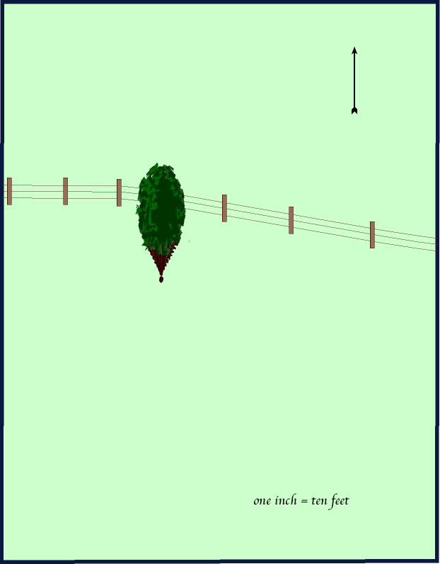
You discover an old diary in the attic of a house you are remodeling. As you leaf through it you find an entry that mentions that the author and another person buried a container 10 feet from the fence and 15 feet from the tree. Suggest how to find the container if it was and still is buried where the author claimed?
Fence and Tree Map
Lab notes 11 - Camp Map exploration
Materials
- Camp map, ruler, paper
Challenge
Use the camp map to answer these questions:
- If you were at the pump which of the following could you see better?
- a. ball field
- b. head of the woods trail
- c. the flag pole
- d. the dock
- What direction is cabin F from cabin B?
- Using the pump and flagpole as a base line locate the cave.
- Starting at the flagpole use one direction (azimuth) and distance to locate the cave.
- How many meters long is the sidewalk from the parking lot to the lodge?
- What direction is the ball field from the lodge?
- What are the dimensions of the lodge?
- Use an azimuth (direction from north) and direction to locate the meteorite.
- What cabin is directly east of C?
- What cabin is west of F?
- Why can’t you locate the ball field?
- What is located on the lake?
- What is the scale of this map?
- Where does the needle of a compass point?
- One cm on the scale is how many meters?
- In real life 1 m = cm
- In real life 1 km = m
- In real life 1 m = mm
Bonus Question 1 inch on the map is equal to how many inches on the Earth?
Lab notes 12 - Yard Map Investigation
Materials
- Maps
Challenge
Use the map to answer these questions.
- What direction is point B from point A?
- Using points A and B as a baseline locate point C.
- Starting at point C use one direction and one distance to locate point D.
- How many meters from C to E?
- Use an azimuth and a direction to locate point C from point B.
- What point is south of B?
- What point is west of B?
- What direction is D from C?
- What direction is A from C?
- What direction is C from A?
- What direction is C from E?
- What are the dimensions of the house?
Bonus: Which two of the following are in the Northern Hemisphere?
Arctic Circle, Antarctica Circle, Tropic of Cancer, Tropic of Capricorn
Lab notes 13 - Review Cartography vocabulary
Materials
Challenge
Match the word on the left to the symbol or definition on the right.
| Word | Match to letter | Symbol or definition |
|---|---|---|
| 1. angle | a. device to measure angles on paper | |
| 2. parallel | b. device to sight angles on Earth (flat sort of) | |
| 3. ray | c. device to sight angles generated from earth up | |
| 4. line | d. ⊾ | |
| 5. triangle | e. 1 cm = 1 km | |
| 6. protractor | f. ⊥ | |
| 7. key | g. north | |
| 8.perpendicular | h. . | |
| 9. clinometer | i. instrument that points to magnetic north | |
| 10. transit | j. ∆ | |
| 11. equator | k. a small unit of angular measure | |
| 12. scale | l. Ð | |
| 13. compass | m. - | |
| 14. point | n. // | |
| 15. line segment | o. this tells what the symbols on a map stand for | |
| 16. degree | p. an imaginary line that cuts the Earth in half north to south | |
| 17. direction | q. ↔ |
Lab notes 14 - Lost at Sea
Materials
- Ruler, compass
Challenge
On a dark and stormy night a radio operator heard a distress call from a ship captain that her ship was taking on water and needed assistance. However, the ship's location was given as five km from Jone's light and eight miles from Fisherman's light. The way the information was given caused the radio operator to question its authenticity. However, due to the seriousness of the possible situation a search and rescue operation was started.
- Your task is to mark the search area(s) on the map below.
- Mark the area(s) that you believe is/are the most likely position(s) of the ship.
- Provide an explanation for your position(s) choice.
Sea Coast map
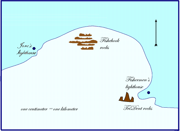
Hints
- Use the scale 1 cm = 1 km and determine how much five km ... & eight km ..., is on the map.
- Find and mark all the possible locations where a ship could be five km from Jones’s lighthouse (compass).
- Find the possible locations eight km from Fisher’s lighthouse.
- Mark with an X at the point or points where the ship might be.
- Decide the best location to send the search crew.
Lab notes 15 - Map making photo log
Materials
Challenge
Use the following to guide your learning and make a photo log to document your drawings, maps, notes, and photographs for learning how to make maps.
- Use a page (electronic or 8 1/2 x 11 inch white paper) to paste a photo related to the activity.
- Use at least one page for each activity.
- Title each page and label each photograph so all references can be located in pictures.
- Be sure the word processor numbers the pages.
- Include a title page containing: a title and group member names
- Include a table of contents.
- If it is not electronic, add a heavy paper cover, back page and bind, staple, or other kind of permanent fastener.
- Make a measuring device. (photo+)
- Do a step investigation to determine step spans. (photo+)
- Make a transit and practice how to use it by locating objects with triangulation. (photo+)
- Learn how to use a compass instead of a transit. (photo+)
- Decide what to map and how to make (measure in? steps, meters, feet, ... measure angles with transit or compass; what scale to use; what Use points of interest as benchmarks, baselines, and points to locate objects and points of interest with: two distances, one distance and direction or angle and distance, and two directions ... ). Make map. (photo+)
Elective activities
- Map an area with a compass. (photo+)
- Measuring height of different objects: basketball hoop, one story building, flag pole, multi-story building, trees, water tower, communication tower (photo+)
- Six ways to measure height
- Make a clinometer
- Measure the height of a grain elevator, tall building, or water tower with a clinometer
- Calculate the height of an object from its shadow
- How to read a contour map of an area. Possibly of Greenland. Use a topographic map of Greenland and corrugated cardboard. (photo+)
- Make a profile map. Select a place like: slope of a surface ditch, side of a drainage basin, or a steep hill. Measure and make a profile map for it. (photo+)
Support materials
Map skills checklist
What I know
▢ Definition of a map
▢ How to use a compass
▢ How to locate points using two distances
▢ How to locate points using one distance and one direction
▢ How to locate points using two directions
▢ Locate positions on a map
▢ How to measure Earth distances from a scale on a map
▢ How to draw Earth distances to scale on a map.
▢ Determine direction from a map
▢ How to make a map
▢ How to use a profile
▢ How to read a contour map
▢ What is orienteering how would you do it?
▢
What I did
▢ Made a measuring cord
▢ Measured the position of objects using
- ▢ two distances
- ▢ one distance and direction
- ▢ two directions
▢ Drew positions to scale
▢ Made a map of
▢ Calculated the height of an object from its shadow
▢ Made a clinometer
▢ Measured the height of a grain elevator, tall building, or water tower
▢ Used a compass to orient a map
▢ Made a transit
▢ Used a transit
▢ Made a map of
▢ Made a profile
▢ Made a model contour from a contour map
▢ Orienteered
▢
Types of maps
Road
Weather
Rainfall amounts
Temperature
Climatic maps
Identify geographical features of the land (mountains, deserts, plains, swamps, lakes, rivers, oceans, ...
Political: countries, states, provinces, counties, territories, ...
Land use
Products
Raw materials
Manufacturing centers
Agricultural areas
Transportation maps
Population maps
Historical maps
Map vocabulary
Antarctic Circle
angle
Arctic Circle
clinometer
cm
contour
compass - directional
compass - circle drawing implement
degree
direction
equator
grid
key - map
km
line
line segment
m
mm
map
parallel
perpendicular
point
proportion
protractor
ratio
relative position
scale
transit
triangle
Tropic of Cancer
Tropic of Capricorn
Map making vocabulary
Azimuth, the distance in degrees (angular) from a fixed direction (north) baseline is a straight line from a benchmark.
Baseline is used to measure contours. It can be made by extending a cord over the contour so that it is level with the Earth, measuring intervals of distances from a benchmark/ datum/ (start of the baseline) along the cord and then measuring the distance from the points on the cord of each interval distance to the point on the contour directly below (perpendicular to) the cord/baseline.
Benchmark is a known location, see datum
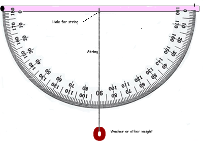
Clinometer is an instrument used to measure vertical angles. Directions to make a clinometer.
Datum is a point, line, or surface used as a reference point.
Declination is a deviation from a specific direction or standard.
Degree is a unit of longitude or latitude. Which is 1/360th the circumference of the Earth or a circle.
Grade is the degree of inclination / slope of a road or other surface.
Gradient is the rate of inclination / slope of a road or other surface
Pace is the distance of a step
- a stride or step, about 30 inches.
- a point measured from where the heel of one foot lifts off the ground to the point where it is put down again after the step of the other foot, or five Roman feet or 58.1 inches.
Transit is an instrument to measure horizontal and vertical angles.
Traverse is the line or web of lines created by sighting and measuring when surveying a tract of land.
Triangulation is a procedure used to locate positions by dividing a region into a series of triangular pieces based on lines of known length that intersect at an unknown point with the other ends joining at the base of a triangle of known length between a benchmark and another known point (selected benchmark/ auxiliary datum)
How far by steps?
Counting steps & distance
History
The Roman soldiers used a technique called double-steps. What they did was to start out on their right foot and when they stepped with it a second time that was one step. The counted in groups of 1000 and called it a “mille passus” Latin, which gave us the word mile and the distance of one mile.
Counting steps for 100 meters
Materials
- Pencil, meter tape to measure 100 m, two markers, partner
- Lab notes
Challange
How many steps would it take for you to walk 100 meters?
Procedure
- Place a marker at what you believe would be a good starting point.
- Measure 100 m and put the second marker.
- Walk to the start and practice taking steps that are equal length and in a comfortable rhythm.
- Walk from the start to the finish, count the steps, and record the result.
- Walk from the finish to the start, count the steps, and record the results.
- Repeat another up and back, count the steps and record the results.
- What is the average for the four trials?
| Trial | Seps for 100 meters |
|---|---|
| Trial 1 | |
| Trial 2 | |
| Trial 3 | |
| Trial 4 | |
| Total | |
| Average |
Extensions
- Compare the walk to a slow jog or marathon pace
- Try different types of surfaces (concrete, dirt, short grass, long grass or weeds, rocks)
- Try different slopes (flat, slight slope, up and down hills, steep slope)
| Double steps for 100 meters | ||||
|---|---|---|---|---|
| Walking | Flat paved | flat grass | rolling hills | Other surface |
| First count | ||||
| Second count | ||||
| Third count | ||||
| Fourth count | ||||
| Average | ||||
| Marathon Run | ||||
| First count | ||||
| Second count | ||||
| Third count | ||||
| Fourth count | ||||
| Average | ||||
Use your data to fill in the following chart:
| Distance & pace | Flat paved | ______ grass | ______ slope |
|---|---|---|---|
WALKING Pace |
|||
| 50 m | |||
| 100 m | |||
| 200 m | |||
| 400 m (1/4 mile) | |||
| 500 m | |||
| 1000 m | |||
MARATHONPace |
|||
| 50 m | |||
| 100 m | |||
| 200 m | |||
| 400 m (1/4 mile) | |||
| 500 m | |||
| 1000 m |
Home: Pedagogy - theory, curriculum, learning, human development, & teaching
Home: Mathematics - knowledge base, activities, pedagogical knowledge in all dimensions
Home: Science - knowledge base, activities, pedagogical knowledge in all dimensions