Oceanography Unit
Last edited - June 11, 2026
Activities, lesson plans, & lab notes
Questioning is the foundation of all learning.
The first step in rejecting not knowing is to ask, why?
Sweetland
Introduction
- Introduction
- Big ideas, concepts, facts, & outcomes
- Science content concepts & outcomes
- Inquiry & science process concepts
- Anticipated learnings & misconceptions
- Pedagogical overview
- Activities sequence
- Focus questions
- Materials
- Scoring guide suggestions
- Unit activity sequence
- Activity 1 -
- Activity 2 -
- Activity 3 -
- Activity 4 -
- Activity 5 -
- Activity 6 -
- Lab notes
- Lab note 1 -
- Lab note 2 -
- Lab note 3 -
- Lab note 4 -
- Lab note 5 -
- Lab note 6 -
- Support materials
A sequence of plans to facilitate a review and develop a deeper understanding of the Earth's oceans, their properties, what's in them, and under them and their importance for lifeon Earth.
Related resources:
Related study topics:
- Matter & Density
- Heat & Energy transfer
- Matter - Water / liquid - has activities for salt water ...
- NOAA - Tides & water levels
Planning information
Learner background information
A plan designed for learners who have prior knowledge in cause and effect, use of observations to make inferences, models as explanations for observable and non observable events, and working in groups.
Intended learnings & learners thinkings
See for more information on what to include in general planning
Content concepts or outcomes
(Source concepts & misconceptions)
Big idea
The ocean is essential for human survival. To protect our species we need to be Ocean Literate.
Concepts and facts
The Essential Principles for Ocean Literacy Source
- Earth has one big ocean with many features.
- The ocean and life in the ocean shape the features of Earth.
- The ocean is a major influence on weather and climate.
- The ocean makes Earth habitable.
- The ocean supports a great diversity of life and ecosystems.
- The ocean and humans are inextricably interconnected.
- The ocean is largely unexplored.
Outcome
Explain the features of the Earth's oceans and explain how humans rely on it for their survival.
Science concepts: physical, earth, life
Earth's Systems (ESS2)
- Water Cycle: The distribution of water on Earth (mostly in oceans) and how it cycles through the atmosphere, land, and ocean.
- Plate Tectonics: Ocean floor mapping, trenches, and mid-ocean ridges serve as core evidence for tectonic plate movement and seafloor spreading.
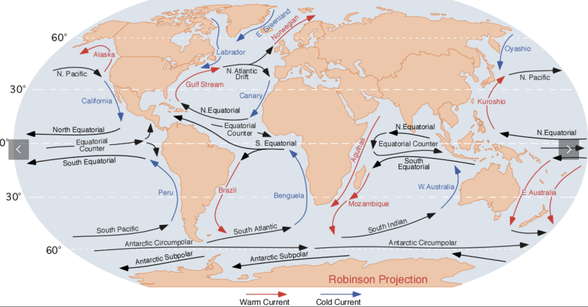
- Weather and Climate: The ocean absorbs and stores massive amounts of solar energy, acting as the primary driver for global weather patterns, ocean currents (like the Gulf Stream), and climate regulation.
- Earth's Features: Waves, tides, and coastal currents constantly shape and reshape coastlines and landforms over millions of years.
Life Science (LS2 & LS4)
- Marine Ecosystems: Energy flows through ocean food webs, beginning with microscopic phytoplankton up to apex predators like sharks and marine mammals.
- Biodiversity and Adaptations: The ocean contains vast, unexplored biodiversity. Marine organisms possess unique anatomical and physiological adaptations to survive in harsh aquatic environments (e.g., pressure, salinity, and temperature).
Earth and Human Activity (ESS3)
- Human Impacts: Humans rely on the ocean for resources (food, energy, transportation) and human activities can negatively affect marine environments (e.g., ocean acidification, overfishing, and plastic pollution).
- Natural Hazards: Tsunamis, coastal flooding, and shoreline erosion can be reduced with well designed engineering solutions to protect coastal communities.
Specific concents and facts
- Earth has five oceans. Indian, Pacific, Arctic, Southern, & Atlantic.
- Differences in temperature create currents.
- Oceanographers map ocean surface temperatures using isotherms. - Isotherms are lines created by connecting places with equal temperatures.
- Water Temperature and Current Direction (in the Northern Hemisphere). If you float on an ocean isotherm with cold water to your left and warm water to your right, the current will push you from back to front.
- Isotherm Spacing and Current Speed. Closely spaced isotherms mean the ocean temperature changes drastically over a very short distance.This sharp temperature contrast creates a steep density slope. The steeper the slope, the higher the pressure difference, and the faster the ocean current flows.
- Warm water is less dense and moves to the sea surface slightly increasing its height (sloping upward).
- Cold water is denser and sits lower.
- Water naturally wants to flow down from warm to cold. However, the earth's rotation generates the Coriolis effect, which deflects the moving water to the right in the Northern Hemisphere. This creates a balanced, stable current that flows parallel to the isotherms, keeping the cold water on its left.
- Major global currents like the Gulf Stream are driven by these intense temperature differences and feature very tightly packed isotherms.
Outcome
- Locate the Oceans on Earth.
- Locate and describe the major ocean currents.
- Explain how currents move with interactions by the Earth's rotation, the Moon's gravity, and different temperatures.
- Identify and describe several animals and plants that live in the ocean. Their key properties, how they get their energy (food web or light), the ecosystems in which they live, and their benefits.
Anticipated learner thinkings & misconceptions
Density is a concept that younger learners will operationalize as heavy (mass). They will not understand that it is a relationship between volume and mass till later. Therefore, when talking about ocean water as more or less dense do to amounts of salt and temperature differences it may be helpful to include activities or demonstrations for density. Like mixing colored water activities 7 & 8.
- Oceans are just water.
- Plants and animals live in all parts of the ocean.
- Dinosaurs made holes for oceans.
- Paul Bunyan made rivers, some supernatural beings made oceans.
- Oceans and floods made mountains.
Inquiry, process, & cross cutting concepts & skills
Inquiry
- When I experiment I collect observations that describe how different properties change (become variables) when objects and systems interact. This helps me make claims, explain what is happening, and to predict what might happen in the future.
- Inquiry concepts
- Process concepts
- Perspective concepts
cross cutting
Big ideas: See also Concepts & misconceptions
Related concepts and facts
- Observational data and reasoning is used to explain interactions. Evidence is something that
is observed and can be used to understand what is happening and make predictions
about future changes.
- Models are structures that correspond to real objects, events, or classes of
events.
- Explanations are based on observation derived from experience or experimentation and are understandable.
- Pictures or symbols represent objects.
Outcomes
- Use explanations based on observations derived from experience, experimentation, and research to prepare and present understandable information about the properties of the oceans and the objects in and under them.
Other possible concepts
History of science and development of technology - perspective of science
See also Concepts & misconceptions also science, math, technology timeline
- People have practiced science and technology for a long time.
- Science develops over time.
- Science investigators such as
Scoring guides suggestions (rubric)
(scoring guide)
Top level
- A
Lower level
Strategies to achieve educational learnings
Based on learning cycle theory & method
Instructional Procedure
Pedagogical Overview
Activities Sequence to provide sufficient opportunities for students to achieve the targeted outcomes.
Make sure learners have the prior knowledge identified in the background information.
- Activity 1 - Water on Earth model
- Activity 2 - Mapping the oceans and their currents
- Activity 3 - Exploring What's in the oceans
- Activity 4 - Ocean motion - Ocean current model with ice, warm water, & pepper
- Activity 5 - Ocean Motion & Earth motion
- Activity 6 - Class ocean mural
- Activity 7 - Measuring ocean depth
- Activity 8 - Human Impact on the Oceans & Conservation of Oceans
Focus question
Unit focus question:
What are the properties of the ocean?
Sub focus questions:
- What can humans do to sustain the oceans for the survival of life on Earth?
Materials
- Links to videos, maps, globe, worksheets in references.
- Lab note 1 - Water on Earth model
- Lab note 2 - Mapping the oceans and their currents
- Lab note 3 - Exploring What's in the oceans
- Lab note 4 - Ocean motion - current model with ice, warm water, & pepper
- Lab note 5 - Ocean Motion & Earth motion
- Lab note 6 - Class ocean mural
- Lab note 7 - Measuring ocean depth
- Lab note 8 - Human Impact on the Oceans & Conservation of Oceans
Resources
Lesson Plans
Activity 1 - Water on Earth model
This activity is Activity 8 in the Pollution Unit and has more related to water and pollution in the unit.
Materials
- Globe, different sized containers, liter, 500 ml, 100 ml, 10 ml
- Graph paper
- Lab notes
Focus questions:
- How is water on Earth distributed?
- How much water on Earth is drinkable?
Challenge
Make a model that shows the distribution of water on Earth.
Learning outcomes:
- Make and describe a model that shows the percentage of water on earth that is fresh.
Suggested procedures overview:
- Put learners in groups, focus their attention, and assess their initial understanding of the focus questions.
- Activity - Make and describe a model that show the percentage of water on Earth that is fresh and where it is located. Fresh water in glaciers, groundwater, and surface water. Salt water in the oceans.
Exploration
- Organize learners into groups and pairs.
- Have each learner decide which finger they want to use as the landing indicator.

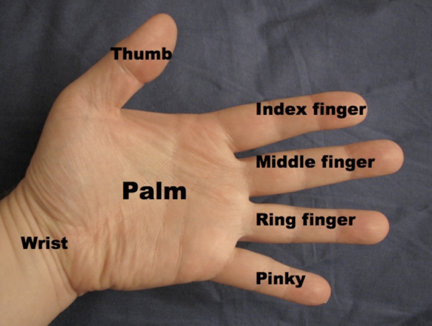
- Tell the learners you will gently toss it them and they will tell if their selected finger is in water or on land. Toos them the globe and they will say (right or left) hand and (thumb, index finger, middle finger, ring finger, or pinky) Repeat tossing the globe, and have another learner record if the position of their choice is on water or land.
- Repeat the toss to all students in the class. If there is less than 25 students, then have some repeat a catch till you get to 25. Or if there is more than 25, you might want to continue to 50. As a mater of fact you may want to do 50 tosses no matter what, so you can just double the amount of selected fingers on the ocean to get a percentage.
- Tell. How can we use the results to determine how much of the Earth is covered with water? Make a fraction. 71/100 or 71%
- Use 1,000 ml of water as the total amount of water on the Earth. Make a model to show how much would be drinkable or fresh water (fresh water can be defined as water that has less than 1,000 milligrams per liter of dissolved solids (salts)). There are three main sorces of freshwater; glaciers, groundwater, and surface water.
According to data from the USGS and NOAA, the vast majority of Earth's water is salt water, with freshwater making up only about 2.5% to 3% of the total.
Here is the breakdown of the distribution of Earth's total water supply:
- Ocean Water (and Inland Seas): ~96.5% – 97.5%
- Glaciers and Permanent Snow: ~1.74% – 2.15% (mostly in Antarctica and Greenland)
- Groundwater: ~0.61% – 1.69% (including soil moisture)
- Surface Water (Lakes, Rivers, Swamps): ~0.009% – 0.022% (freshwater lakes, rivers, etc.)
- Atmosphere: ~0.001% (as water vapor)
- Use the containers to show were the water is located. Fresh water in glaciers, groundwater, and surface water. Salt water in the oceans.
- Ocean is about 970mL and 30 ml fresh (3%).
- Of the 30 ml or 3% being located with 70% is in glaciers, 29% in groundwater, and 1% surface water.
- Use this information to redistribute the 30 mL of water. 21 mL glaciers, 8.5 mL represents ground water, & .5 mL represents surface water. in containers and label them.
- Discuss.
- Most learners are truly shocked when they learn about this. Provide time to process.
- How truly limited drinkable water is.
- The consequences of glacier melt.
- How important groundwater is.
- How limiting surface water is.
- H0w pollution is more consequential when the source of fresh water is so limited.
- How would these be represeented on a sheet of graph paper to show ... 3% of Earth's water is fresh, 97% is ocean or salt water. with the 3% showing that 70% of it is in glaciers, 29% in groundwater, and 1% surface water?
Invention
- Regroup as a class and groups demonstrate their models with water. and graphing.
- Share their graph paper representations.
Activity 2 - Mapping the oceans and their currents
Materials
Focus questions:
- What do you know about the location of Oceans on Earth?
- What do you know about how their water's flow?
Learning outcomes:
- Label a map with the position of the Oceans.
- Draw and label the major currents in the Oceans.
Suggested procedures overview:
- Put learners in groups, focus their attention, and assess their initial understanding of the focus questions.
- Activity - Review maps and label a map with the position of the Oceans and the major currents in thems.
Exploration - .
- Put learners in pairs.
- Ask. What do you know about the Ocean?
- Record for all to view. Might want to group their ideas by the Ocean properties below.
- Tell them. You can use this property list to add to it as we learn about the properties of the Ocean.
Properties of Ocean Water
Physical properties related to ocean water
- Salinity: Total dissolved solids (salts), and how evaporation and freshwater input affect it.
- Temperature and Density: The relationship between temperature, salinity, and water density (e.g., how cold water sinks).
- Pressure: The concept of increasing water pressure as depth increases.
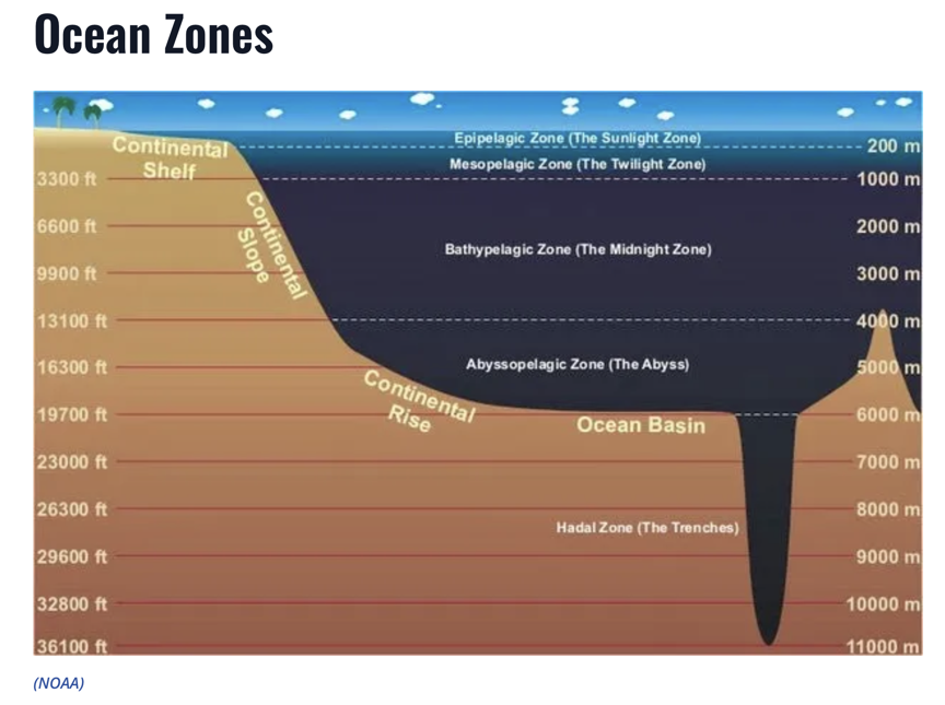
Ocean Zones
- Light Levels: Photic (sunlit) vs. aphotic (dark) zones and their effect on photosynthesis.
- Depth Zones - Surface zone (mixed), transition zone, and deep zone.
Ocean Motions
- Surface Currents: Driven by global winds and the Coriolis effect, often moving in large loops called gyres.
- Deep Ocean Circulation: Thermohaline circulation driven by differences in density created by temperature differences.
- Waves and Tides: The formation of waves (energy transfer) and tides driven by gravitational pull.
Ocean Floor Features
- Continental shelf, slope, and rise.
- Deep Ocean Basins: Abyssal plains, trenches, mid-ocean ridges, and hydrothermal vents.
Ocean and Earth Systems
Climate and Weather
- The ocean stores and transfers heat, impacting global weather patterns.
- The Water Cycle - the ocean is the primary driver of evaporation and precipitation.
Organisms in the ocean
- Animals
- Plants
- Other
Human Impacts
- Ocean acidification,
- Pollution marine debris,
- Ocean resource management
- Tell the learners. We are going to explore these properties after we locate the Oceans and their currents on a world map.
- Map the location of the Oceans on the World Map
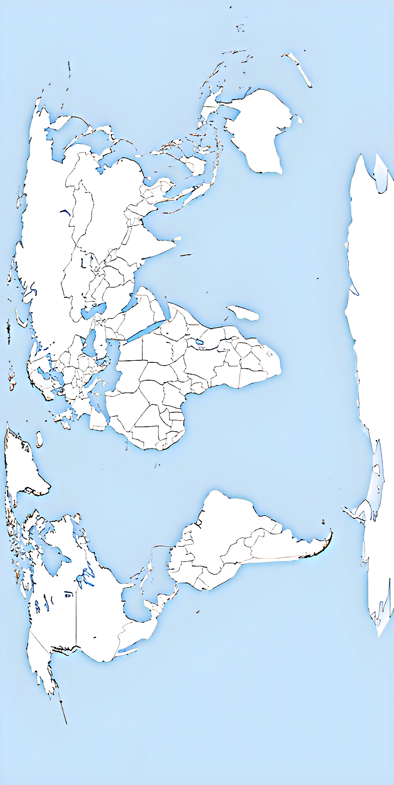
- Use the Ocean currents map and add the currents to your map.
Invention -
- Review the locations of the Oceans and currents.
- Explain that you will be doing some explorations to understand more about the Ocean currents in the coming activities, but they are going to watch some videos about what is in the oceans so they can learn about those properties and also to think about what organisms they might pick to do a deep dive aboiut them and present what they find to the class. (PUN intended)
Discover
Review properties of oceans and current in coming activities.
Activity 3 - Exploring What's in the oceans
Materials
- Ocean maps
- Video PBS - Oceans: What's under the surface (7:04)
- Video - Draining the Oceans (.34)
- Lab note
Focus questions:
- What do you know about what is in and under the Ocean?
Learning outcomes:
- Watch videos, identify some basic ocean zones, the geography of the Earth's Oceans, their floors, and map and diagram their characteristics in their lab notes and add to class properties list.
Suggested procedures overview:
- Put learners in groups, focus their attention, and assess their initial understanding of the focus questions.
- Activity - Watch videos, identify some basic ocean zones, the geography of the Earth's Oceans, their floors, and map and diagram their characteristics in their lab notes.
Exploration - .
- Put learners in pairs.
- Review the class list of what they know about the Ocean and say we are going to be adding to our list and their lab notes.
- Ask. What do you know about what is in and under the Ocean?
- Add to what has been recorded and reorganize as desired.
- Tell. You are going to watch some videos about what is in the oceans so they can pick some organisms to do a deep dive into and present what they find to the class. (PUN intended).
- Watch the Video on PBS - Oceans: What's under the surface (7:04)
- Review and note ... the following information under the appropriate categoreis in the class tree or map.
Ocean properties
Light in ocean zones (sunlight, twilight, midnight).
Temperatures: Mixed layer, (55degree F,) 0 - 200 meters, Thermocline 200 - 1,000 meters, Deep water (39 degrees F)
Geography: Continental shelf, continental slope, abyssal plain, oceanic trench,
Mariana Trench
Ocean Ranges
Bay of Dundee
Map and video shows the oceans and drains them to show the ocean floors
Draining the Oceans (.34)
Ocean movements - currents
Variables that affect ocean currents: turning of the Earth, Tides, Temperature differences
Motion of waves, up and down till reach shore.
Invention -
Discover
Activity 4 - Ocean Motion
Materials:
- Clear container (about 5 liters), semi-hot water, cold water or ice, pepper, plastic bag.
- Lab note
Focus questions:
- What causes the ocean motion?
- How can we model the flow of currents in the ocean caused by different temperatures?
- How does water flow?
- How is the experiment relate to the Ocean's currents?
Learning outcomes:
- Differences in temperature create currents.
- Oceanographers map ocean surface temperatures using isotherms. - Isotherms are lines created by connecting places with equal temperatures.
- Water Temperature and Current Direction (in the Northern Hemisphere). If you float on an ocean isotherm with cold water to your left and warm water to your right, the current will push you from back to front.
- Isotherm Spacing and Current Speed. Closely spaced isotherms mean the ocean temperature changes drastically over a very short distance.This sharp temperature contrast creates a steep density slope. The steeper the slope, the higher the pressure difference, and the faster the ocean current flows.
- Warm water is less dense and moves to the sea surface slightly increasing its height (sloping upward).
- Cold water is denser and sits lower.
- Water naturally wants to flow down from warm to cold. However, the earth's rotation generates the Coriolis effect, which deflects the moving water to the right in the Northern Hemisphere. This creates a balanced, stable current that flows parallel to the isotherms, keeping the cold water on its left.
- Major global currents like the Gulf Stream are driven by these intense temperature differences and feature very tightly packed isotherms.
Suggested procedures overview:
- Put students in groups, focus their attention, and assess their initial understanding of the focus questions.
- Activity - Explore temperature change model and explain: What causes the ocean motion? How can we model the flow of currents in the ocean caused by different temperatures? How does this affect the water flow? How is the experiment relate to the Ocean's currents?
Exploration
- Put learners in pairs.
- Put the ice or cold water into the plastic bag and seal it.
- Fill the large clear container with semi- hot water.
- Stir in some pepper until you have a fair distribution of pepper.
- Let the water motion settle down.
- Slowly lower the ice bag into one end of the container.
- Observe the current.
Invention
- Recall and review .
- What directions does the pepper go relative to the ice?
- What about relatve to the warmer water in the other end of the container?
Activity 5 - Ocean Motion & Earth motion
Materials:
- Videos -
- Diagrams -
- Lazy susan, bowl,
- Lab note
Focus questions:
- How does the Earth's motion cause the ocean motion?
- How can we model the the relationship of the Earth's motion to the motion of the Ocean?
Learning outcomes:
- Explain how the Ocean tides are caused by the gravitational pull of the Moon and Sun, combined with Earth's inertia and rotation, which pull the oceans into two alternating bulges. These two science experiments model and demonstrate how these forces shape our oceans
Suggested procedures overview:
- Put students in groups, focus their attention, and assess their initial understanding of the focus questions.
- Activity - Explore
Exploration
- Put learners in pairs.
- Watch and discuss the NASA animatition of tides - models gravity interactions, high & low tides, solar and moon tides combined, spring and neap tides.
- Draw models to show the moon's force related to tides.
Invention
- Recall and review .
How does the Earth's rotation affect the motion of the Earth?
Spinning Turntable (or Lazy Susan) Experiment
Demonstrate how a straight line curves on a rotating planet.
Materials:
A lazy Susan (or rotating tray), a circular piece of paper, a ruler, and a marker.
Procedure:
Tape the paper to the tray.
Spin the tray counter-clockwise (representing Earth's rotation).
While it spins, try to draw a straight line from the center to the outer edge using the ruler. - Hold the ruler above the paper and move the pencil along it from the center to the edge as the paper spins.
The line will curve beautifully on the paper, showing how straight-moving currents are deflected by rotation.
The Swirling Water Tub Experiment
Models the Coriolis effect combines with land boundaries to create amphidromic points (the hubs of swirling tides).
Materials:
A circular plastic tub, water, a drop of food coloring, and a lazy Susan
Procedure
Fill the tub with water and place it on the lazy Susan.
Spin the tray steadily counter-clockwise.
When the water is moving, gently squeeze one drop of food coloring into the outer edge of the water.
The dye will swirl into a circular pattern around a calm center point, perfectly mirroring how actual ocean tides rotate around the glob.
Discover
- How do ocean currents affect weather and marine life.
Concepts
When used in association with water, the term "current" describes the motion of the water. Some currents you may be familiar with are the motion of rainwater as it flows down the street, or the motion of the water in a creek, stream, or river flowing from higher elevation to lower elevation. This motion is caused by gravity. The speed and direction (velocity) of currents can be measured and recorded.
Oceanic currents are driven by several factors. One is the rise and fall of the tides, which is driven by the gravitational attraction of the sun and moon on Earth's oceans. Tides create a current in the oceans, near the shore, and in bays and estuaries along the coast. These are called "tidal currents." Tidal currents are the only type of currents that change in a very regular pattern and can be predicted for future dates.
A second factor that drives ocean currents is wind. Winds drive currents that are at or near the ocean's surface. These currents are generally measured in meters per second or in knots (1 knot = 1.15 miles per hour or 1.85 kilometers per hour). Winds drive currents near coastal areas on a localized scale, and in the open ocean on a global scale.
A third factor that drives currents is thermohaline circulation - a process driven by density differences in water due to temperature (thermo) and salinity (haline) in different parts of the ocean. Currents driven by thermohaline circulation occur at both deep and shallow ocean levels and move much slower than tidal or surface currents.
The Currents Tutorial is an overview of the types of currents, what causes them, how they are measured, and how they affect people's lives.
Rotate a cup slowly and the water inside will push the water in the direction of the rotation.
Bulge and rotation makes tides
From bulge to low is about 6 hours or 24 hours from
high to low (6) to high(6) to low(6) back to high(6)
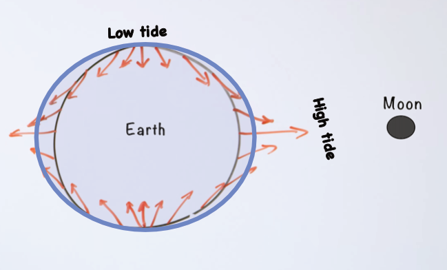
Law of universal attraction between objects f= force of gravitational attraction, G is the gravitational constant, m1 is the mass of one object, m2 is the mass of a second object, and r is the distance between the center of the two masses.
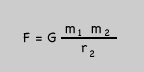
Since the distance is squared it changes considerably over distance as represented by the orange force vectors. This difference is one force that affects the motion of water currents.
Activity 6 - Class ocean mural
Materials:
- Wall covered in blue craft paper, sic foot by eight foot, resource books or access to online references for ocean organisms. Markers, wordprocessor, printer, ...
- Marine life encyclopedia
- Lab note
Focus questions:
- What are the organisms in the ocean?
Learning outcomes:
- Research and report on one organism that is a producer and one that is a consumer.
- Understand how animals adapt to different ocean zones.
Suggested procedures overview:
- Put students in groups, focus their attention, and assess their initial understanding of the focus questions.
- Activity -
Exploration
- Put students in pairs.
- Ocean Life and Ecosystems Objective: https://ocean.si.edu/ecosystems/deep-sea/ocean-zones
- Introduce different types of ocean life: through classification
- Marine mammals
- Fish
- Reptiles
- Crustaceans
- Mollusks
- Cnidaria
- Echinoderms
- Plankton
- Algae
- Seagrass
- Write the different type where you can list examples and other notes.
- Ask. What organisms doyou know as examples of the different types? List the examples with the class.
- Watch the video: Learn 50 sea animals in English. (9:58)
Maybe for younger audiences, but it does have clips of 50 actual animals. if you are asking your students to draw their selected animal, you could convince older learners that the initial pictures can illustrate how artist try to simplify them for younger children or how to make them more interesting, or to think about how they will illustrate their selection. Might discuss if this is good or not. What advantages or disadvantages there is to try to make animals look better?
- Activities: Sort photos of ocean creatures by zone, small-group research on one animal, share findings. Plan: 15 min intro, 25 min group activity, 10 min presentations.
- Have each learner select one consumer and one producer to research, illustrate, and report on.
Invention
- Recall and review list of ocean types.
- Each student reports on their organism: Name, size, in what ocean zone it inhabits, illustration, other properties, how it gets its energy, life cycle, .
Discover
A Powerhouse species in peril
https://www.science.org/doi/10.1126/science.aeh0749
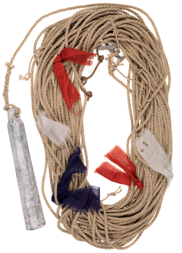
Activity 7 - Measuring ocean depth
Materials:
Prepare an ocean.
I got a very large paper towel box from my local grocer. Along with another box tout up and make the ocean floor in the bottom of the large paper towel box. Then I covered it with blue craft paper from a roll, left a very narrow opening lengthwise along the top to insert a fishing sinker weight tied to a piece of twine. Then I used meter stick to make a mark every 5 centimeters.
- Cardboard box and extra boxes or pieces of cardboard, lead sinker, twine, meter stick, Graph Paper.
- Lab notes
Focus questions:
- How is the depth of the ocean measured?
Learning outcomes:
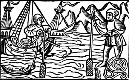
- Ancient mariners measured the depth of the ocean with lead and line.
Suggested procedures overview:
- Put students in groups, focus their attention, and assess their initial understanding of the focus questions.
- Activity - Measure the depth of the box and explain how it is a model to explain how ancient mariners measured depth and how it can be related to a model of a depth finder using sonar.
Exploration
- Ask. How do scientists measure the depth of the ocean? Ocean depth - Sonar, submersibles, ROV's.
- Introduce echolocation by bats, dolphins, and sonar.
- Compare sonar to bouncing a ball from a foot off the groud and six feet off the ground. The time it takes to go down and back can be measured and divided by two and the speed of sonar in water.
- Mention. Sounding, which ancient mariners did with lead and line. Tell them they are going to use lead and line to map the bottom of the ocean you made. Just like ancient mariners did.
Herodotus (-440 BCE): Recorded in his Histories (Book 2, 5), this description: "... approaching the Egyptian coast and using a sounding lead sailors brought up mud when the ship was still a day's sail from land.
- Put learners in pairs. Explain they will take turns while working on their reports and drawings for the class mural.
Invention
- What
Discovery
- Discuss how
Activity 8 - Human Impact on the Oceans & Conservation of Oceans
Materials
Focus questions:
- How does
Learning outcomes:
- Learners
Suggested procedures overview:
- Put students in groups, focus their attention, and assess their initial understanding of the focus questions.
- Activity -
Exploration
- Ask.
Invention
- Ask. How
Discover
Objective: Recognize pollution and ways to help oceans.
Activities: Examine photos of ocean pollution, brainstorm solutions, write a pledge for ocean care.
Plan: 15 min visual discussion, 20 min group brainstorm, 15 min pledge writing.
Beach safety - riptides , sun, buddy,
Story map on beach safety with videos showing six dangers
Write a plan for a beach visit.
Activity 9 -
Materials:
Focus questions:
- What
Learning outcomes:
- Explain
Suggested procedures overview:
- Put students in groups, focus their attention, and assess their initial understanding of the focus questions.
- Activity -
Exploration
- Organize learners into pairs and groups.
- Have learners
Invention
- W
Discover
- If
Activity 10 -
Materials
Focus questions:
- How do
Learning outcomes:
- Describe
Suggested procedures overview:
- Put students in groups, focus their attention, and assess their initial understanding of the focus questions.
- Activity -
Exploration
- Organize learners into groups and pairs.
Invention
- Regroup as a class and groups demonstrate their projects.
- Ask.
Discover
Lab Notes for activities
Lab notes 1 -
Materials
- Globe, different sized containers, liter, 500 ml, 100 ml, 10 ml
- Lab notes
Focus questions:
- How is water on Earth distributed?
- How much water on Earth is drinkable?
Challenge
Make a model that shows the distribution of water on Earth
Record the data from the Earth globe catch.
Use the data below to discuss how to make a model of water on Earth
According to data from the USGS and NOAA, the vast majority of Earth's water is salt water, with freshwater making up only about 2.5% to 3% of the total.
Here is the breakdown of the distribution of Earth's total water supply:
- Ocean Water (and Inland Seas): ~96.5% – 97.5%
- Glaciers and Permanent Snow: ~1.74% – 2.15% (mostly in Antarctica and Greenland)
- Groundwater: ~0.61% – 1.69% (including soil moisture)
- Surface Water (Lakes, Rivers, Swamps): ~0.009% – 0.022% (freshwater lakes, rivers, etc.)
- Atmosphere: ~0.001% (as water vapor)
Use the containers to show were the water on Earth is located.
Discuss.
How does this information change the way you think about
The availability of drinkable water is.
The consequences of glacier melt.
How important groundwater is.
How limiting surface water is.
H0w consequential pollution .
How would you represeented this relationship on a sheet of graph paper?
Lab notes - Ocean properties
Write everything you know about the Oceans in ten minutes.
Lab notes 2 - Oceans and their currents
Materials
- World Map
- Lab notes
Focus questions:
- Where are the Oceans of the world.
Challenge
List the Oceans of the Earth.
1.
2.
3.
4.
5.
Enter the locations of the Oceans on the map.
List the major currents in each?
Lab notes 3 - Properties of Oceans
Write ocean properties from class videos and discussion.
Physical properties related to ocean water (Salinity, temperature and density, pressure)
Ocean Zones (Light Levels - sunlit, dark zones and effect on photosynthesis)
Ocean Motions (Surface Currents, waves, winds, tides (gravity), the Coriolis effect & ocean circulation by density & temperature differences)
Ocean Floor Features (Continental shelf, slope, and rise, deep ocean basins: abyssal plains, trenches, mid-ocean ridges, and hydrothermal vents.
Lab notes 3 - Ocean depth activity
Materials
- Cotton twine, with permanent marker lines every centimeter, lead weight, Graph Paper
Focus questions:
- How d
Challenge
Herodotus (-440 BCE): Recorded in his Histories (Book 2, 5), this description: "... approaching the Egyptian coast and using a sounding lead sailors brought up mud when the ship was still a day's sail from land.
Use a lead weight and cotton twine to measure the depth of the ocean floor in the ocean box.
Record the depth every two centimeters.
o cm
2 cm
4 cm
6 cm
8 cm
10 cm
12 cm
14 cm
16 cm
18 cm
20 cm
22 cm
24 cm
26 cm
28 cm
30 cm
32 cm
34 cm
36 cm
38 cm
40 cm
Support materials
B
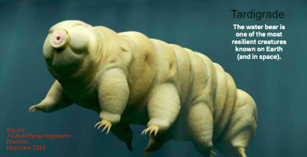
Tardigrades can survive crushing pressure of the ocean floor, DNA shredding radiation, the vacuu of space and eventemperatures just 1 degree above absolute zero, and hte evaporation of all the water in their cells. Don't believe it.
Research ... American Scientist article - Tardigrades
World map
Lead and line
Graph paper
Home: Pedagogy - theory, curriculum, learning, human development, & teaching
Home: Science - knowledge base, activities, pedagogical knowledge in all dimensions